Catalogue for our Antique, Fine Art and Collectables auction held on Wednesday 17th of June 2026
Auction Categories
Return to main sections
Viewing 1
12 sub categories viewing : Map in Paintings, Watercolours, Prints, Sculpture and Works of Art
12 sub categories viewing : Map in Paintings, Watercolours, Prints, Sculpture and Works of Art
description ( and estimated value in GBP )

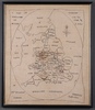
862
Robert Morden (c.1650-1703), "Midlesex" (Map of the County of Middlesex), late 17th/early 18th century engraving with hand-colouring on laid paper, 40cm x 45cm, within a Hogarth style frame.sold for £30

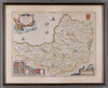
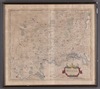
895
William Blaeu, "Somersettensis Comitatus. Somersetshire" (Map of the County of Somerset), 17th century engraving with hand-colouring, 38cm x 50cm, within a Hogarth style frame.sold for £80

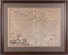
906
Emanuel Bowen, "An Accurate Map of the County of Kent Divided into its Lathes", 18th century engraving on laid paper, 54cm x 72cm, within a stained wood frame.sold for £40